According to all the hydrology textbooks there exist three types of river that can be defined according to the topology of their channels: straight meandering and braided:
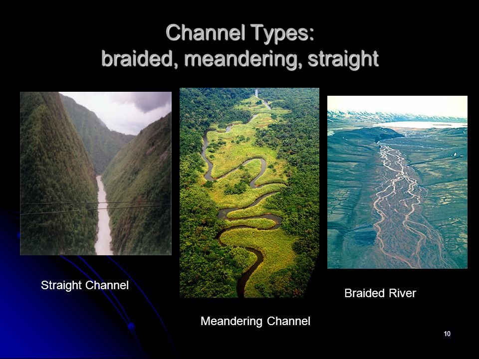
That sounds very clear and simple enough, But it all started going pear shaped when I tried to understand why braided rivers form: because if they are a unique form of river, then there ought to be something causing them.
However, as the following shows, there is no clear cut change from a meandering to a braided river. Instead natural rivers exist in a variety of forms, the same river often appearing meandering with islands, but also the individual channels within a “braided” river meander:

I started getting suspicious when I tried to pin down the supposed reasons causing braided rivers. And then it all stated getting very nebulous: Braided channels are most common in areas of moderately steep gradient (so steep), but they also occur in low gradients like Deltas (so not steep) and in areas of variable discharge (variable) but also in deltas where there is constant discharge (constant).
So as a last resort I went to Wikipedia: “Braided rivers, as distinct from meandering rivers, occur when a threshold level of sediment load or slope is reached whilst a steep gradient is also maintained” – that sounds as if someone knows what they are talking about. Except that doesn’t explain deltas. Nor does it explain any real river where the flow is constantly changing and with it the sediment load (in flood, most rivers have a massive sediment load compared to “normal” conditions).
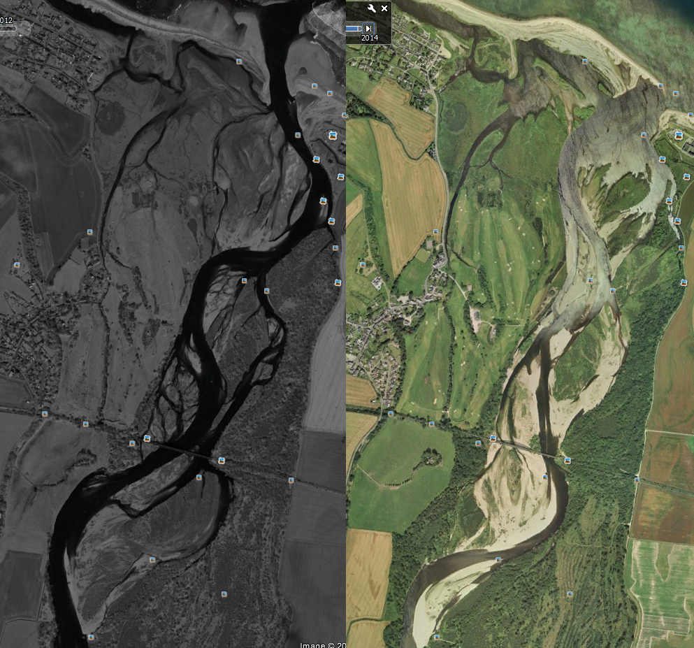
And then it all goes totally nuts when you start looking at actual river like the Spey:
Here we see the same section of river, in 2012(left) and 2004 (right). From this we can see the same river is heavily braided in 2012, but in 2004 the same part of the river is now what would be described as “meandering” … that is unless we don’t look at the water and instead look where the vegetation is not growing. Now when we look at the lighter areas which clearly have flowed in floods, the river is braided.
But now let’s go back to the Wikipedia page and look at their iconic image for a “braided” river:
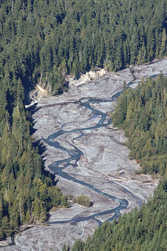 Hang on a minute! If we follow the water – the river may have the odd island, but I think there is clearly only one main channel for almost the entire length shown. Far from being braided, the channel shown here is clearly not. Instead, what is really “braided” … if the word has any meaning … is the flood channel. Or to be really cynical, perhaps someone was told this was a braided river – and they put the photo in without looking at the actual river that was flowing?
But it is also very clear that what makes this channel shown above distinct is that the river fulfils the following condition:
Floods occur often enough and with enough destructive power so as to remove all vegetation from the river and its “flood valley”.
In other words, if the river flooded very irregularly, then for most of the time the land around the river would be covered in vegetation. If however, flooding occurs regularly enough so that vegetation does not have time to grow in between floods, then the land will be bare. Likewise, if the flooding is slow-moving water which does not disrupt the surface, then even if it does flood, the vegetation can survive.
However what I am finding looking at aerial photos is that if we ignore the vegetation and consider all levels of water, it is very difficult to decide whether a river is or is not braider. Take for example the following Google earth images of Cairo Ohio:
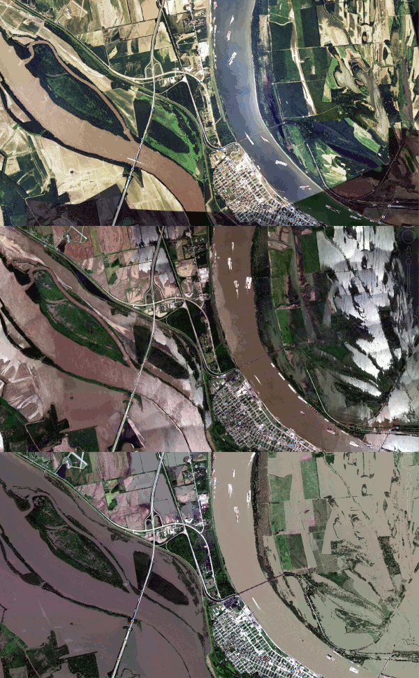 It is clear that the large elongated “island” (to a large extend defined by the channel) on the left is “normally” dry land. But in some floods in becomes an island – but in severe flooding it appears that the entire surface is under water and this “island” in the severest floods is merely part of the river.
So, how do we define this river? Is it meandering or braided?
But what about this river (below)? Here because the river bank has been built up (presumably to stop flooding), the meandering line of the river is clear to see. But it exists within what is a fairly straight river valley. As such, this would “normally” be considered a meandering river, but in flood, the flooded river is clearly a fairly straight river.
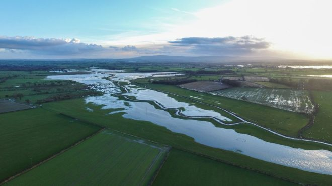
So, when you examine rivers at various levels of flood, the categorisation of the river changes. But if this categorisation “belonged” to the river, then surely it ought to be fixed and immutable? This has led me to the conclusion that there is no such thing as a braided river. Instead it seems “braided”, “meandering” and “straight” are descriptions of types of flow and all rivers to more or less extent exhibit all these features at various flows. So there is no such thing as a “braided river” only a “braided flow” – or level of flood. So I would like to suggest the following framework:
At peak flood all rivers are “straight”**
At peak flood rivers behave like a “straight” river (**as normally defined by hydrologists and in diagram above) in that they follow their river valley down to the sea. And what is more, they cannot be braided in peak flood, because the “braided islands” only exist because flood builds them up. And for this to happen, there must exist floods whose level are higher than the “braided islands”. So any “islands” in flood will be geological features that divide the flow and not braids.
At minimal flow all rivers are “meandering”
By definition, if the flow is a minimum, then the trickle will take the lowest channel and therefore because it takes the lowest channel, there can only be one.
In between minimum and peak flow, all rivers exhibit some braided behaviour
As a river changes from minimum to maximum flow, it goes through a series of states gradually filling up more and more channels until it overtops the islands in between to again become a single channel. As such a braided river does not exist as such. Instead a braided river is merely a state of flow greater than that needed for a single channel and less than peak flow.
Flows
The key to this discussion is that most river flows are highly variable. Below is a graph showing the flow of a typical UK river:
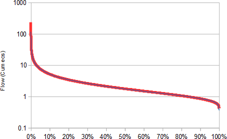 This shows that around half the time, the river is below a couple of cumecs (cubic meter per second). But a few days each year it is above 10cumecs and at times over 100 cumecs. But conversely a few days each year it is well below “normal flow” – but that’s the issue! There really is no such thing as “normal flow”. Instead what we can say is that most of the time this river is around 1-10 cumecs – and order of magnitude change of flow is “normal”.
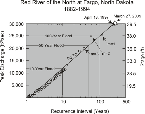
But there’s a similar issue with floods.
The above graph is pretty typical in that it shows a logarithmic relationship between peak flow level and frequency. And because it is the flow during floods that carves the landscape and river valleys, even a flow that occurs as seldom as once in 100 years can be the dominating factor carving a valley that formed in the last ice-age. (100 100yr-frequcency floods can have more impact than 10,000 years of 1yr-frequency floods or 100,000 “peak flows in any month”).
Discussion
The key thing is that there really is no such thing as a “normal flow” – particularly when we are considering flows that carve river channels. Because whilst everyday or every-month flows occur relatively frequently, it is the massive and infrequent flows that have the most effect. As such there is no such thing as a “normal” flow in terms of the “normal” effect on a river channel because it is the infrequent flows that normally define the river.
So what we “normally” see in a river is usually not the river flow that defines the river. So surely the river should not be defined by the water level at this flow!
The “normal” river it is merely a reduced flow that happens to fill the channel to whatever level it happens fill them at that supposedly “normal” flow. Thus the occurrence or otherwise of “braiding” is just the mere chance that the flow on the day the hydrology observes it happens to fill more than one channel.This is not what is “normal” in terms of the channel, but what happens to be the flow that day.

Thus going back to the above picture a “straight river” is merely a river whose flow is such that it is constrained by the geology (such as the valley in which it flows) and not river hydrology. A meandering river is a river whose flow is well below the level of the next higher channel. And a braided river, is one whose flow is above that of the “next lowest” channels, but not above that of the highest “braided islands”.
Now, we can say that a meandering river is no different from a braided river, instead in practice all channels are meandering, and at peak flow, they are merely curving slightly deeper bits of the river. The illusion of a braided river is that it just happens that on some rivers when we think the flow is “normal” that not all the channels present at peak flow will be both: 1) filled with water and 2) not linked together at the surface by the over-topping of the intervening “braided islands”.
ADDENDUM
The main reason I post is to try to set my thoughts out – and help me think through problems. After I posted I realised that if the river at low flows contained a lot of sediment and tended to deposit material, then the deepest channels would tend to infill thereby equalising the depths and so encouraging water to take several channels at once.
That therefore would suggest rivers that appear braided for much of the time will be infilling deeper channels for much of the time with the result that the general profile is broader and shallower.


With that image of the braided river – would not a coarse underlay with clumps of dense shrubs cause the “braid”?
The river comes down solid and meets the easier coarse way, gets deviated by the dense shrub roots. then splits when it hits the next dense clump (with easy passages each side).
I can see it’s a rather specific set of circumstances that create the braid river (maybe that;s why they aren’t all that common).
I’m guessing that braided rivers tend to be on either poor soils (eg new volcanic material or sand). Whereas meandering rivers are on silt and clay. The plant life plays a strong role. Soil that easily washes away, washes away the plants that hold the meandering features together during flood periods. Or just doesn’t encourage plant growth at all. If the floods are big enough, even the meandering river can forge a new path but it then starts building more meanders. A meandering river might not change its course in 100 years but a braided river changes every time there is a flood.
Deltas have the potential to form longer features because of the silt/clay + vegitation but are the result of powerful rivers, where full flood can overcome almost any barrier to carve a new channel. So are not braided rivers as such.
I went swimming in Glen Etive yesterday and it was noticeable that whereas the lower river looks obviously braided from satellite pictures, the same banks and multiple channels existed even on water falls – except they weren’t obvious unless you sat down on the rocks near the waterfalls and wondered why there were no plants on them.
And the same is true of any river – most people have no clue that the “flood plain” on which their houses sit is part of the river channel. That this part of the channel is only filled once every hundred or thousand years is neither here nor there geographically.
And the reason rivers need to be treated this way, is because a few days of a 1-in-1000 year flood shape the river channel/flood-valley more than 1000 years of “ordinary flow” – or maybe not??
This may be the real distinction: that if a river channel is primarily determined by the very rare event, then it is one sought of river, whereas a river whose channel is primarily moulded by more regular events is another. Indeed – since at some flow level the probability of lower flows must start to become less, there could be a peak regularity of flood which because of the combined effects of probability of occurrence and the effect on the channel, has most impact.
I was thinking of the Victoria falls and had much the same thoughts.
Even most V shaped rivers meander and divide but with sharper turns.
All river diversions are caused by the water continually seeking an easier route. Fast moving water goes over or through, slow water can be persuaded to go around and some of the time there is no obviously better route so the water splits. Where there are turns there is erosion and deposition that may make one route better than another. Human development interferes.
I was thinking about Kendal and the river deciding that the route through the town was the best one. It will be hard to prevent it trying again. The flats that were washed away in Tyneside a few years ago were in the way of an old culveted route, where the culvet failed. The soft infilled land was no match for the river.
So fundamentally there is no difference between river types other than slope, volume and obstruction. Between the groups there will be a lot of overlap.
I’m sure someone will have said it somewhere – but it seems to me that the “purpose” of rivers curving is to allow distance for the frictional effect. That is to say: the river above a particular speed will tend to erode the banks – but the more in meanders, the longer it travels and the lower the gradient. So a straight river rapidly erodes a new course – until the channel goes enough from side to side to create enough “friction” to slow the river speed below the level at which erosion occurs.
Pingback: Understanding rivers | Scottish Sceptic